The Cliffs
Slieve League Cliffs
Sliabh Liag – Ireland’s Majestic Sea Cliffs
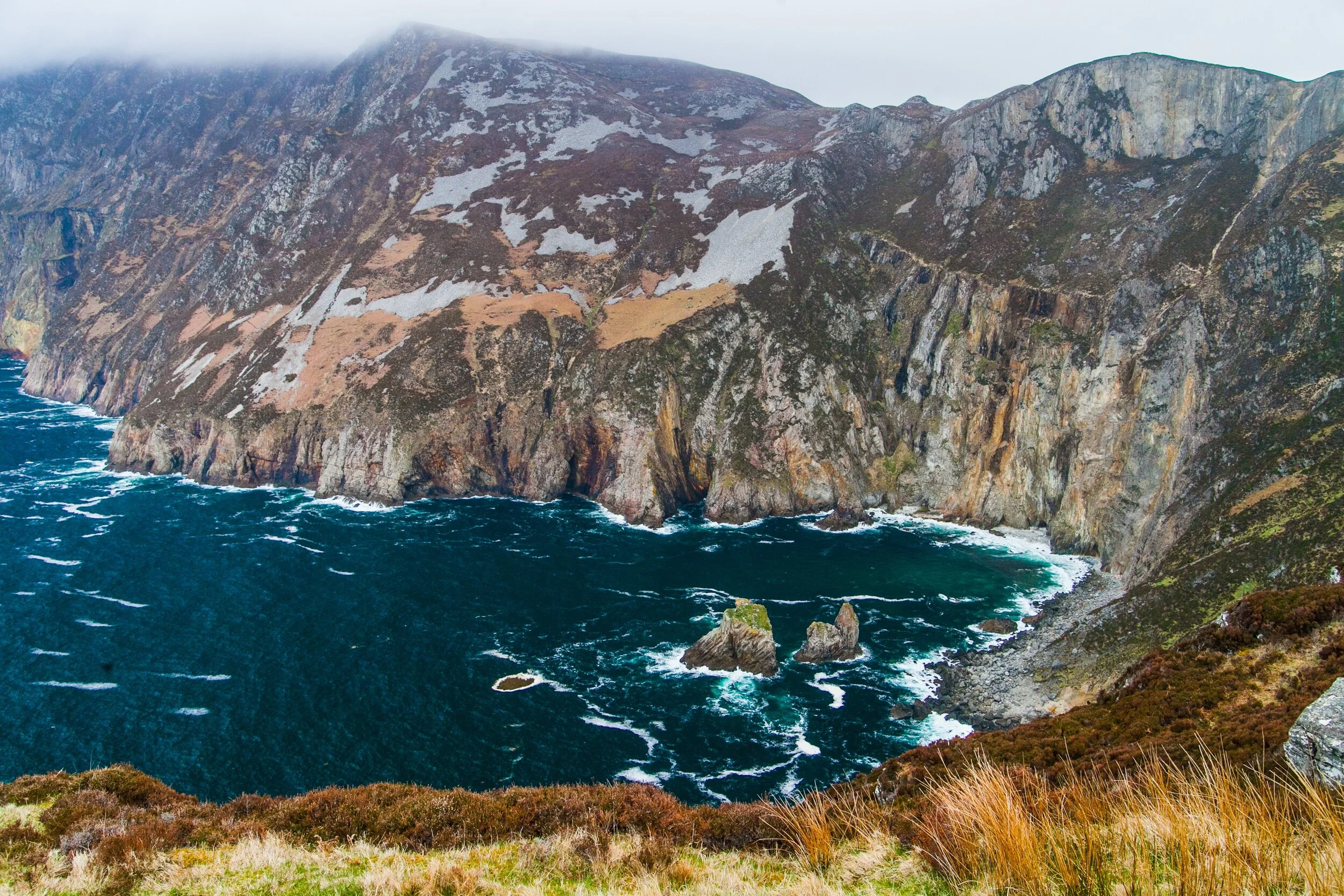
Rising almost 2,000 feet (598 meters) above the Atlantic Ocean, Sliabh Liag (Slieve League) is among the highest sea cliffs in Europe. Offering one of the most breathtaking views in Ireland, this rugged natural wonder is a must-visit destination for those seeking spectacular scenery and deep-rooted Irish heritage.
At nearly three times the height of the Cliffs of Moher, Sliabh Liag rewards visitors with an unrivaled panoramic vista. From the viewing point, you can take in Donegal Bay, stretching toward Leitrim, Sligo, and Mayo, while the vast Atlantic Ocean unfolds endlessly to the west. Looking northwest, you'll spot Rathlin O’Byrne Island and Glencolmcille, while at the cliff’s base, keep an eye out for the famous "Giant’s Desk and Chair", a striking rock formation tied to local legend.
A Landscape Steeped in History and Mythology
Beyond the breathtaking views, Sliabh Liag is deeply woven into Ireland’s history and mythology. From here, you can see Benbulben, a table mountain linked to Finn McCool and Irish folklore. Nearby, Carrowmore is home to one of the largest Neolithic cemeteries in Europe, dating back to 3200 BC. Offshore, Inishmurray Island holds the ruins of an early Celtic Christian monastery, while further along the coast in Mayo, Killala marks the landing site of the French forces during the 1798 Rebellion against British rule.
Closer to home, Carrigan Head is home to one of the Napoleonic-era signal towers, built by the British to monitor potential French invasions. Atop Sliabh Liag, you’ll find the remains of an early Christian monastic site, including Aed Mac Bric’s chapel and ancient beehive huts, where monks once sought solitude and spiritual connection.
For the adventurous, One Man’s Path offers an exhilarating walk along the cliffs’ edge, leading to a trig point placed atop an ancient structure of unknown origin. Revered as a sacred mountain, Sliabh Liag has been a site of Christian pilgrimage for over a thousand years, and visitors are encouraged to respect its archaeological and spiritual significance.
Sliabh Liag and WWII: The Donegal Corridor
During World War II, Ireland remained neutral but reached agreements with the Allies, one of which was the Donegal Corridor—a designated air route allowing Allied aircraft to fly over Irish territory from Enniskillen to the Atlantic. As a navigation aid, large stone ÉIRE markers were placed along the coastline. One such marker is still visible near the Sliabh Liag viewing point, though now partially overgrown, with another found along the descent from the cliffs.
Experience Sliabh Liag
With so much history, heritage, and breathtaking beauty, a single visit isn’t enough to take in all that Sliabh Liag has to offer!
Before or after your hike, stop by the Tí Linn Café for a delicious meal and a hot cup of coffee—perfect for warming up after your cliffside adventure.

